Thursday, January 10, 2013

What Did Your Feet Look Like?


The Feet.
As anyone could imagine, hiking 1864 miles in 43 days has to take a toll on your body, let alone your feet that take the impact of each and every step along the way. I lost count of my blisters at around 25, had a toe nail infection begin about 2/3's of the way through that lasted until I was off trail, and the balls of my feet were constantly sore. That said, my body did a remarkable job at trying to protect my feet. It was amazing to see the thick calluses that formed. It took 2 months of relatively non-use for my feet to shed all the calluses and get back to normal. 2-3 weeks after getting off trail, this is what my feet looked like...

Even my hands had burly calluses from trekking pole use...


September 29, 2012 - Off Trail


July 7, 2012.

Day: Off Trail   Daily Miles: 0   Total Miles: 1864   Hours Hiking: 0   


September 29
I have just finished transcribing, nearly word for word, all of my audio journals from my 2012 speed record attempt and I must say I’m relieved that time consuming task is complete. Having lived it, recorded it and then had to listen to and write every word of it down has left me with the feeling that I never want to hear this again. Yet, at the same time, I have had the strange experience of being inspired by myself, which is odd, because I know I have done these things, yet at the current time could not repeat them without a great deal of training. Usually in life, we know what we can and can’t do on a daily basis, but when you get into the realm of something as ridiculous as hiking 40+ miles a day for 42 days…well, it seems nearly impossible except for the fact that I have done it. Even with the first-hand knowledge of how little fun it was and then having it be retold again to me through the transcription, I’ve had thoughts of trying it again. I am happy with what I was able to accomplish, however there is a certain feeling of incompleteness that might one day drive me to attempt it again. That’s definitely a big bag of mixed feelings. For now, I think there are many more other things to do in the world than try and set a record I’m confident that I can do. For now, the money will stay out of where my mouth is, because to attempt it again (and knowing who I am and that I will probably try and up the ante) it is a huge commitment, and sacrifice in sanity and day-to-day happiness. Overall, it went well. I know where improvements need to be made and what to do differently if I should be so crazy as to try again. It’ll be just as hard, maybe even harder because I know what to expect now. Sometimes ignorance is blissful, because you don’t know if around the bend you have to climb a saddle or drop into a valley. My main hope in transcribing this is that others will read it and gain some insight of experience that they will never have. If I can muster up a little inspiration in others, it’ll be worth far more than any records I managed to set.
Silver Pass Panorama looking at Lake of the Lone Indian.

July 13, 2012 - Off Trail


July 13, 2012.

Day: Off Trail   Daily Miles: 0   Total Miles: 1864   Hours Hiking: 0   

Listen to the audio journal above or Download July 13th Audio File Here


July 13 – Off Trail
Feet up with the view of Diamond Lake on my last day on trail,
July 13th, I'm back in California. I'm driving down to San Francisco. I spent about 13 hours yesterday driving. This is just an update on how I've been feeling and such. I don't know, last night I started thinking about stuff and I really...my mind, just feels numb. Physically my body hurts a bit. I don't have a whole lot of energy. I've been eating more or less without thinking. If there is food available, I just throw it into my mouth unconsciously. I'm like 'why did I just eat half of the bag of chips when I only thought about having a handful or two.." *laughs* Stuff like that. My knees hurt, my right knee especially, but it was actually hurting me on trail, so that no surprise...there's something going on with that. I'm a little hesitant to take big steps even with my own weight, because I know it's going to hurt. Maybe 1 in 50 steps it will hurt, so my body is weary of them. I did 10 push ups the other day, which I was quite surprised that I could still do 10!, but I'm actually sore from doing just 10 push ups. So that's funny. The biggest thing I've noticed is mentally I....I feel just mentally numb. I know I have been suppressing...I haven't been thinking about much of ANYTHING for the last 1.5 months, besides do the miles, get this done. It's been like the one-track mind. I've been listening to audio books and completely not using my mind, how about that. So, it feels numb and thinking about 'my life', what I'm going back to and things...it feels like I've forgotten all the little details, which isn't bad, it kind of feels like this clean slate where I just have the feeling where I'm like ' I should....I can go do anything..I can start anew'. It's kind of a strange feeling, it feels nice, you know all of these little details and things, little nagging things you think about are just gone. So I have this fairly strong urge or feeling to just go in a completely different direction with my life and I don't have a clue where that is...I don't know what I want to do at all, I mean I'm kind of living day to day right now. So like planning stuff...yeah, I don't want to plan anything at the moment. It's umm, it's really strange, I didn't expect this. But, at the same time, when you're set on something for 1.5 months and completely working yourself into the ground and life goes from living in the corner of suburbia preparing...trying to think of every single detail that could possibly go wrong so that you have a smooth hike to all your goal is for the day is to hike 40-some-odd miles, find water and eat food. Yeah, things get cut and life changes from highly complex to very very simple... and I think that's the adjustment I'm trying to make right now. I don't really remember it taking much or being hard last time, but last time I had things to do right away, already planned out - going to the southwest for a week with my girlfriend and another 4 days off then I was flying to New Zealand to help my friend do field work. So within 3 weeks of finishing the trail last time in 2009, I was doing stuff. I had no recovery time. And now that I have recovery time, I've taken this week off, I've got all my panoramas stitched together and just hanging out and doing nothing, it's really strange. This hike was definitely more intestthan my 2009 one, and...umm...I don't know, I just feel numb and dead. *laughs* Like I don't really have feelings towards any one thing. It's kind of like 'ahh whatever, I could do that, I could do this...I don't know what I want to do'..But I don't want to do what I was doing...how about that. That's about as much as I know right now. Which doesn't mean that I don't want to go back to Colorado..it just means I just want to try something new and venture off in some other direction, which I've said like 5 times, but in slightly different ways, so I'm going to stop talking about it. It's one of those things that I didn't expect, but feels strange but good that I'm actually feeling it. So that's how it goes.

Addition
July 13th again. It...I have, these weird... because I've been so independent and umm... you know basically by myself with no one to really hike with for the last 1.5 months, I have this another strong urge to just go hang out in the desert by myself again, to let myself readjust to stuff. That in itself is unexpected. On trail you do get lonely. I can only assume that I am wretchedly lonely right now, but it just doesn't come to the surface. Every time you see a person {on trail} you stop and talk with them for about 5 minutes. I think it's kind of strange that I'm like 'all I want to do right now is get away...I don't want to go into cities, I don't want to deal with people... I just want to go somewhere and hang out...' The desert, the southwest somewhere, is where I'd want to do it, besides it being bloody hot right now. But in another vein, I kind of feel like what the hell am I doing with my life...jack shit... what's this whole earning money thing and well I just hiked for 1.5 months to try and break a record and you know I'm doing my own thing...but where does that get me, what am I doing it for. I kind of want to like go backpack - just go buy a flight to India and just hang out and see the world or...I don't know...go to Africa and volunteer...*laughs* I think I want to do something that's different. That's definitely... this whole pollen thing, cool. Work..normal job, doing all this crap, living in suburbia... ehhhh it's fine, but I don't think I want that right now. We'll see how it goes. Give me a week or two and things might change when I get back and settled and kind of readjusted a bit more. But that's how I feel right now and it aaaaa, yeah, interesting.
Crater Lake Rim sunset, day 42.


July 7, 2012 - Off Trail.


July 7, 2012.

Day: Off Trail   Daily Miles: 0   Total Miles: 1864   Hours Hiking: 0   

Listen to the audio journal above or Download July 7th Audio File Here


July 7 – Day after Stopping
Mt Thielsen, the day before...
July 7, I'm officially off trail. I hiked zero miles today, but I figured I'd give a little recap of what happened. I woke up behind a big pine tree right next to the Diamond Lake Resort. I went down to the store and bought laundry detergent, soap and shampoo, then went and did my laundry in the public laundry there. It was pretty funny because I was washing ALL of my clothes {including the ones I was wearing} so I was wrapped up inside my tarp and there were guys there doing repairs to the other washing machines. It's just funny because they're in there talking and they just see me in my tarp and that's all I'm wearing. It was just silly. There was a woman on the other side of a little partition separating the resort's laundry area and you know, they're just talking back and forth like no big deal. So I got my laundry done, I ate a pint of ice cream on my walk down to the showers...I had a 16oz Bush beer and I was just enjoying not having to hike. The real feelings of being off trail really hadn't sunk in yet. It still kind of felt like a zero day, which I had had none of. It, I guess, felt like a resupply day, because I still have all of my stuff and I'm still completely on my own, self sufficient. So I walked down... I had to walk about a mile to get down to the showers at the campground. I had my big bar of soap, my shampoo. I get into the stall and I probably spend a half hour in there. I washed my hat, washed my shoes out because they were nasty from the previous days snow and walking down the dirt and stuff...And then managed to wash myself, which was awesome. I was clean! I had all clean clothes! You feel like a new man really. It's like a resupply, every time you feel that much better. I got out of there and walked back to the resort where I found out that my mom was going to be coming to pick me up pretty soon, so I just hung out on the big grass area out in front of the resort. It was a Saturday so it was pretty busy...maybe a Sunday, I don't remember. I just hung out in the sun relaxing. Not moving was a wonderful thing. I bought a can of frosting and ate some of that with all my extra cookies that I had bought at Crater Lake. A couple with two kids sat next to me on this double picnic table and started talking to me. I explained what I was doing and blah, ba blah and they got really excited and she sounded really cool actually. Other than that, my mom showed up and I get picked up and I finally was talked into going up and seeing their house in Washington, so we proceeded from Diamond Lake on up to Warm Beach Washington. That's a good ohh 6.5-7 hour drive. We stopped off at Big Lake Youth Camp where I picked up my boxes that included a new pair of shoes and food and all my resupply stuff I would have picked up in a couple more days had I continued on hiking. That was good that I got all of my stuff from there. We arrived up in Washington round about 12am and for the hung out up there and basically didn't do anything for 4 days. Today is the 12th when I'm actually recording this, I'm driving home or back to Northern California. I'm going to stop by Cascade Locks to pick up my other box that was sent ahead there. I spent the time in Washington organizing my photos, I stitched together 100 panoramas that I had taken. Organized, deleted and got everything sorted. I have more work to do on those... I played computer games and just relaxed. I ate a hell of a lot of food. I'm actually trying to cut back just a little bit now, because I don't actually need to put on 20lbs in a week. I'd rather put it on over a couple weeks and slow my metabolism and bodies reactions down. My right knee hurts, it's still fairly sore even though I'm not really using it. It definitely was a problem spot that was overlooked while hiking. So everything is....my body just needs to readjust. It hasn't even been a week yet and I'm gaining a little bit of weight back, that's for sure, but not nearly what I need to. I need to work on gaining muscle back while my body is still in the mode to build muscle and use whatever I've got. So I'm headed back down a nice 850 mile drive, somewhere around 12-13 hours. From there we'll see, just take it day by day. I don't really know what I want to do with my life right now, so it's good and bad. I kind of feel like its a time for a new beginnings. This is done and over with and I need some recovery time, but at the same point I want to start something new and go from there. We shall see. I'm definitely OK with what all has happened. Sure, it would have been nice to finished, but I did get an email from Jack at the PCTA and he was like "yeah, I was wondering when you were going to hit it, I had known for a couple weeks now that the snow was bad' So it was just a matter of time and when you hit it you finally were going to say 'quits'. It wasn't quite... it was too early for a...to try for a record. I got a message from Scott Williamson's wife, he is flying up to Washington on Monday, which would be the 15-16th and is going to hike around in Washington for a week or two and then he's going to go southbound for another record attempt. So she said he'll be bummed that he won't be crossing paths with me. He was hoping to meet up. But otherwise, it's just how it goes. I'm happy with having the new California and midpoint records. Anything else would have been bonus. You know 42.5 days or so is plenty of hiking, especially at averaging 44 miles per day, so that's something to be proud about. Nothing to look down your nose at. It's just how it goes.
Mt. Thielsen and the snow covered trail, the day before.

Day 43: July 6, 2012


July 6, 2012.

Day: 43   Daily Miles: 16.75   Total Miles: 1864   Hours Hiking: 11   7:15am-6:00pm

Listen to the audio journal above or Download July 6th Audio File Here

Day 43
The flats before heading up to Mt. Thielsen - no snow!

July 6, Day 43. Today actually turns out to be my last day on trail. The snow was basically so bad today that it took me 8 hours to go 10 miles next to Mt. Thielsen, and judging by where it {the snow} is now currently at about 6000 ft in the trees and what the conditions are like...projecting that forward to the rest of Oregon and Washington as well, making the record is going to be nearly impossible. If I was planning on...yesterday I was thinking about if I could make 40's then I can still beat the record by like 2 days or so. But at this pace, yesterday I only made 35, umm yeah, it would be impossible basically. So, I just decided to quit. I mean I was going to give it a few more days to see how far I could get and see what my timing was - hopefully get to Big Lake Youth Camp. But, I got to a point a little ways away from the high point for Oregon/Washington, and there was a trail back down to Diamond Lake and knowing what I know, and what time of day it was and that I might not find a good spot to camp, I said screw it {after a couple phone conversations at the trail junction} and hiked down to Diamond Lake, where I knew I could get a ride out. I spent the night down at Diamond Lake, right up off of the road next to the resort in no mans land. That point being 0570282 E 47804187 N. I stopped/got off trail at mile 1864, at the Howlick Trail, making the grand total of that day to be ohh, 16.75 roughly. So not even 17 miles for a majority of the day. I actually left down to the trail at about 6pm. Anyways, lets see here. I started off in the morning. It wasn't so bad. I had gotten out of the snow from the previous day, down from Crater Lake and was out in the flats - the big volcanic flats area, just lots of pumice and ash, which makes the soil sparsely treed with lodgepoles - not every big ones and pretty thin. You come to clusters that are more dense than others. The mosquitoes were bad regardless of where you were. I slept pretty much right on trail - nice flat
Yup, that's the trail. The icy steep horror.
ground, almost 5 miles away from highway 138, or where you cross it. The morning hiking was just fine. There quite a few blow downs across the trail actually - not very hard to get around, small trees, small lodgepoles. So I made pretty good time getting to the highway. There was some water cached at the highway because it is supposed to be a 25 mile dry stretch. Or at least now flowing water, which it turned out to be the 25 miles and then some. I crossed the highway and started going up and within about 2 miles or so, the snow patches began and maybe 0.5-1 mile after the snow patches began, the trail kind of turns to cross a north face and the snow patches became more continuous and steeper. They turn into an almost continuous snowfield on the trail because it's a flat surface, making a great platform for these huge snow drifts to build and pile up. So I'm crossing these pointed, mini ridged hills, that are steep, hard snow in the shade, for pretty much the rest of the day. Once the snow started, it was 95% snow for the next 10 miles. There was very very little dirt or trail to be had. It was treacherous going for a majority of the day. These big snow piles are steep, they melt out in weird ways, meaning that you usually have to walk this thin ridge, a little knife edge, across them, otherwise you have to kick steps and walk across the face, where if you fall, you're going to slide down 5-10 ft into a tree because it's so steep. I plodded along for a while, having to break out the GPS to figure out exactly where the trail was. The difference between fighting snow in the trees versus, say above tree line up in the Sierras is that in the trees you don't know where you're going. Whereas in the Sierras, you have a general since of the trail is heading towards that saddle, or down this valley, so you can more or less stick to the valley and make your own trail, and you pop out and can find the trail real easy. Where, in the trees, you could be trying to contour along at one elevation and the trail goes way up, then all of a sudden you realize when you hit a ridge that the trail is somewhere, where you are not. So you have to kind of keep close to it. It took probably a couple hours to get over to the Mt. Thielsen summit trail along a nice ridge, which if you were to try and avoid the snow, it
Reprieve from the snow, Diamond Lake in the background.
would be real easy to take this trail as a bypass for about the first 5 miles or so of nasty snow. It seems to follow up a southward facing ridge, so the snow should more or less be melted out and you won't have to deal with the treacherous trail up until that point. The backside of the ridge where you get a nice view of Mt. Thielsen, is a complete snowfield. That area was actually pretty nice because it is fairly open, the trees were gone. I worked my way down into a couple of big open snow fields, soft snow, so I didn't have to worry about footing as much, so that made it real easy... and then you get back into the trees where it looks like an avalanche has come off Thielsen and bowed a bunch of trees over. There is a big pile of dead ones at the bottom. There was some activity within the last couple years, maybe even this year. A lot of the trees were pretty messed up (laying at low angles} which made it a little hard going to go through the border of the forest. Then, back into the forest, conditions didn't really change much. They did change from tall snow drifts at the beginning, eventually to these big giant snowfields on fairly steep slopes, where there was no abundance of snow on the trail, there was just a slope of snow you had to walk across and try and figure out where the trail was. The bad part about that is, it's hard snow, so you have to kick each step, and you have to worry about consecutive steps. And if you were to slip and fall, you might have 20 ft before there was a tree in your way, however around each tree is this void-space, the snow has been melting out around the trees faster. Usually there is 2-3 ft radius around the trees that has melted out to a 3-4 ft depth. So, if you were to fall, you would slide, then enter this 3ft pit and then hit the tree, so it's just bad news all around if you were to slip and fall. I managed to get up and over the next ridge, had to climb down a 4 ft cornice and then shoe
Mt. Thielsen at the summit trail junction.
ski/glisade or otherwise slide down about 150-200 yards to get down to where the trail was. I took a little short cut just because the trail takes you on a couple switchbacks and stuff, where I just cut them. I finally get to Thielsen Creek and umm, it's supposed to be my first flowing water from the last 25 miles and it is actually completely covered in snow. There is no flowing water to be seen, I can't hear any flowing water. The snow is probably 3-4 ft thick over the top of it. You can see where the creek should be, but there is no water. I had a little bit of water because I had been stuffing my water bottles with snow, but I needed a bit more water to facilitate the melting. I went for another half hour and finally found a stretch of trail where the trail itself being a little trough, the snow bank above it was melting and filling the trough flowing down the trail. So at the lower end snow bank, I dug out a spot for my water bottle and proceeded to fill up my water bottle as much as possible with the water that was slowly trickling down the trail from the melting snow bank. I managed to get both of them pretty full, but with quite a bit of debris...that was interesting and delicious, but at least I now had a source of water that I could drink quickly and use to melt other snow with. I literally got water directly off the trail...drank water directly off the trail. I kept going, the snow stayed the same....the continuous steep, hard, sloped - the trail winding it's way through the trees. From then until more or less where I stopped, it was really a constant battle of having to second guess everyone of your steps, because of the consequences of not having a good foothold were pretty dramatic. Not that it would kill you, but the end result if you didn't stop in time before you hit a tree could lead to some serious complications, just in the way that your legs might fall into the hold and or get spread around the tree...it just was not good. I finally got about a 100 yard section of clean trail at one little ridge that was facing to the south, but then come around the corner there's this near vertical 10ft slanted...I mean it's a really steep slope with no footholds. The hardest part actually is that there are no other footsteps to follow, so I had to
Snow crossing from the ridge with the Mt. Thielsen summit trail. 
literally blaze the trail more or less. There are a few faint ones here or there from Swami or Insane Dwayne. But they were very few and far in-between and not reliable. That part it took me another 10 minutes to get up and around it, I had to cut steps...I found that my trekking pole if you stab it a bunch of times in one area, you can break out a little foothold and make it better by kicking it. So I finally made it across that. It's super steep...I took photos, to try and explain it, but it's a lot steeper when you're standing on the side of this mountain and looking down to where the snow would take you when you fall, and knowing that your foot is only maybe 1/3 planted in this snow because it's so hard and you can't get a full foot kicked into the wall, so you're just making these tiny half steps - quarter steps into the snow and walking on those. Thank god I had trekking poles, otherwise I would have been...yeah...even slower. At the same token, if I had had crampons, I would have felt much safer and probably could have gone at a somewhat reasonable pace, just because you don't have to worry about every step you're taking...your foot is in, you're set and you can make the next step and not have to worry about it. So that's a consideration for future attempts, or other people. Crampons - have a supply ready and don't be afraid to carry them because if you get to a point like this, they are going to save you a bunch of time. Anyways, the slope finally kind of leveled out a little. I hiked up to a big scree slope/boulder slope and walked across the boulders instead of having to punch through the snow. Then I cut down and over to the trail. Where I finally hit the trail, I check the map, did the math and figured out that I only did 10 miles in 8 hours and I was at a trail that lead me back to somewhere where I could escape relatively easily and get picked up
Below Mt. Thielsen at Thielsen creek.
easily.... versus if I kept going I'd have another 10-15 miles above 6,000 ft, which would probably mean more snow, which would mean going slow, and then I would drop down and finally be out. To negate the extra amount of extra work I would have to do, I said screw it all, this has taken me the last 2 days to basically go 52 miles. So that should have been 1.25 days. So it was slowly wearing me down and taking my time, and I feel like I...the snow was the final nail in the coffin, whereas if the trail was clear or there were just little snow banks, it would have been totally fine, I would have kept going, kept pushing. But, knowing that it was going to be that way for a while longer, and slowly whittling down my lead that I have gotten, that was too much really. The lead I've gotten is not something I wanted to whittle down just to break the record, but something I wanted to continue and pull through the entire time. If I'm already 4 days ahead with only 800 miles to go, I want to finish by being 4 days ahead, not being like 'well I was 4 days ahead, and then it was reduced to 1...I still broke the record by 1 day but if conditions were better I would have really been able to really kill it'. It's kind of one of those quit while your ahead. I knew that the snow was going to be a big damper, it just takes that much more out of you. It's a full body workout versus just your legs, because you have to balance, use your arms, you have to mentally think about each step and worry and....for all it's worth, it wasn't worth it, therefore I called it. I hiked down the Howlick trail, which was pretty snow free actually. It was amazing to drop down just a little elevation and to see how it changes. The trail looks to be a snow magnet, because when you get a little lower, it turned into not so bad. Once the slopes you are on lessen in their grade, travel becomes much easier, but that's not where the PCT is. It likes to stick to
Choose you're own icy adventure trail..
the crest, the high points and that's where it becomes hard. So, I hiked on down, the mosquitoes were thick...I finally crossed Thielsen Creek as it was flowing...it was flowing pretty damn well. I filled up my water again - it was some great water, kept going and finally exited the trail about a half mile away from the Diamond Lake Resort at the horse campground area. I walked down to the resort, went into their laundry area, charged my phone. By this time it was about 8:30pm. I did a few things on my email and online and such and then just walked out of the resort. I found a little place about 50 yards from the highway, nestled behind this big giant pine tree with nice duff and spent the night there. I even tired to sleep in a little bit.
Mt Thielsen at Thielsen. This was supposed to be the first water source in 30 miles..,it's all under snow!

Day 42: July 5, 2012


July 5, 2012.

Day: 42   Daily Miles: 35   Total Miles: 1847.25   Hours Hiking: 16.5   7:00am-11:30pm

Listen to the audio journal above or Download July 5th Audio File Here

Day 42
Evening

EVENING
Through a burned area about 15 miles before Crater Lake.
July 5th. I sit here on the rim of Crater Lake, looking down as a slowly setting sun behind me casting shadows across the lake onto Wizard Island. It's about 7pm, it's a really picturesque day. Big puffy clouds in the background. Beautiful and clear all the way across the lake. The golden light streaming across the grass next to me, the dead tree on the point next to me as well. Wizard Island overlook is off to my left, to the north and the hiker PCT on the rim trail is the absolute epitome of hard. It is so choked with snow and unmarked and hidden and steep and erratic that it....well the whole day has been covered in snow, and I have definitely hit way more..5 times at least, 10 times probably at least, more snow in the last 20 miles than I have had the whole entire time along the rest of the trip. It it makes for slower going, that's for sure, and most of it I have hit in the flats, which I know that's going to change once I move on a little bit into the mountains. So, right now is the first time I'm seriously considering stopping. Before it's a daily struggle, and in the end I always have the motivation to keep going. And right now, with the prospect of having Oregon choked with snow, and Washington, because they both had abundant snow years, and even late snows. I'm here now and I know that my mileage per day is going to suffer, and at the same time, if I reduce, say to even just 40 miles a day, I'll still beat the record but at the same time, that's not really what I'm going for. I feel like I've done all this work so far...and in the one hand, yeah, it's wasted if I don't finish, but at the same time, you know, I feel like, if I'm going to do something, I'm going to do it right. Finishing about a day and a half early and doing 10x more work for the record, I'm not sure it means that much to me. I mean I've already had thoughts of stopping just because I'm unhappy and I'm over it. And this, just makes things worse. I've sat here for about 25 minutes. I have another, ohh, 6 miles to go along the rim.
Fresh bear prints on the snow.
I have no idea if it gets better....it better. I hope it gets better. If it doesn’t I'm going to road walk, because it is absolutely horrific. I would much rather be on the equestrian PCT right now - going mostly flat and hitting snow drifts versus these gigantic walls.... many of them are corniced...tough snow on this steep slope on a trail that basically just bobs up and down and is really hard to follow. So, it's um, yeah... it's kind of one of those points, those pivotal moments where I want to keep going. I know there is going to be more snow. I know it's doable, but at the same time is it worth the effort? Currently, I am at least 4 days ahead of the record and today I might not even make 30 miles because I resupplied and I have this horrific trail situation, truly. And I know from here on out it's just going to be a daily battle to even try and make the miles. If it was clear, I don't think I would stop, I would definitely finish and accomplish what I set out to accomplish. I mean I already feel like I've accomplished what I personally wanted - doing really well up until this point, testing what my physical and mental endurances are. And, having done that, I don't think that 20 more days of pounding through snow is going to prove that anymore to me, besides the fact that I am a masochist and that *laughs* I actually...I don't know...that doesn't truly prove anything more to me. Like, the record in itself, all depends on weather and conditions. I mean if it was clear, that's why southbound is 'so much better' of a way to do it. At least for trail conditions, because you leave when the snow is gone and the Sierras are totally clear. But this is slightly unexpected. I had warning about it, but it is much worse than it had ever seemed to be. A majority of today wasn't that bad. I was only probably an hour and a half behind, but this trail...I came up from the equestrian PCT on the hiker PCT and 1.5 miles of it was snow. I mean there was no trail. I'm glad I have a GPS, or otherwise I wouldn't have found the trail, and actually I met two people that were trying to hike up the trail to the rim road - a father and son, and they were coming back down because they said they had lost the trail. Well I was like ' I have a GPS' and they asked if they
Where's the trail...under the snow!
could follow and I was like 'sure thing!'. So I lead the way for two other people to get up, that's how hard the trail is, because there is no trail. We're probably the 3rd 4th and 5th people to do it this year, and it's completely covered. At many points today, I hit the same thing. You're in trees and you go about 20 ft from the last place you saw the trail...and it's all snow and you don't know which way it goes. You have an idea, but the snow just stretches on and on, and you can't tell. The trees are pretty equally spaced, there are no marks, so it's very frustrating...and you know...it's... it's the extra push to say 'why am I actually doing this?' I mean if it's just a trail to follow and hike all day long that's doable. This is a whole different ballgame entirely. So I feel like I've going to push on and if it stays similar, then I'm going to quit, just because I really feel there is no point to push on and really beat myself up and go through the hoops just to barely scrape by with the record. I mean after all, the record was the goal in which to judge myself with and thus far I've bested the record by a good deal. Granted, it's not the full record, but allowing for trail conditions, it would be nearly impossible I think to actually do it completely at this point in time due to the conditions. So, it just comes to a balance..... and there are sooo many mosquitoes up here, I don't understand this. There's no standing water besides the lake and the lake is like 500 ft below me and yet there is a cloud of mosquitoes constantly following me. That adds to it too, just the general nuisance. I haven't had it this bad since the Tuolumne area. I can see Mt. Thielsen barely, just sticking up over the ridge through a little saddle off to my left, to the north. Tomorrow, if everything goes as planned, I'd hit the highest point in Oregon and Washington. If
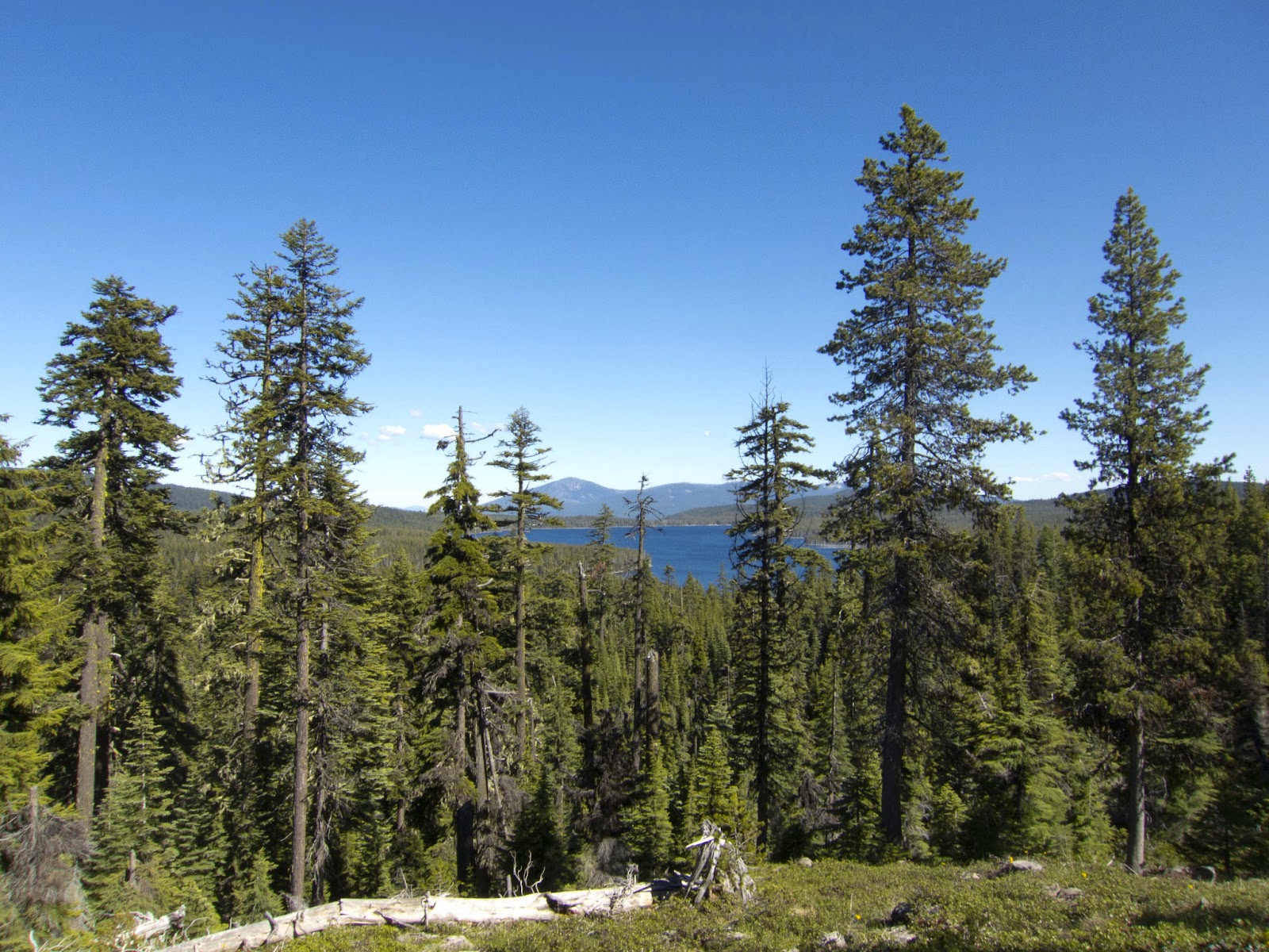
Crater lake in all it's glory. Still so much snow.
that's not covered in snow, I don't what is... So it's.... I looked at the map, and there is a good section down around 5,500 ft, but even then, I know from last night that there were snow patches, not nearly as difficult, but when you go up on Mt Adams, I believe is next, so you go up Thielsen, up Adams to the sisters, which all of those are at 6000 ft, which I was at all day today and was in tons of snow. And if you're in the trees...being Oregon, they are dense trees... and so the snow can't melt out, unless it's really clear. Even on the east or west slopes, I had bunches and bunches of snow that wasn't melted. So, it's going to be extremely tough and the overall result will be less than I want...and if that's not reason to quit.. It's not particularly a great reason to quit, just because things get tough and you quit but when you're going for a speed record, if you can't make what you're going for, why keep putting the effort into it? If I was doing this as a normal thru-hike I could take days off, I could go slow. Even if I go slower now, I have to rearrange my whole food scheduling, because right now I think I have it set for a 46-47 mile a day pace. So if I only make 40's everyday, I'm going to be short at least half a day when I get down and around to my next resupplies, and that's a problem, especially when you get to places like Big Lake Youth Camp, which is my next resupply, there's no store, and it's too late to have extra stuff sent. So I'm stranded, especially since I can't hitch to anywhere. So it's a bunch of logistical things that also add in. That's my thought. I gotta get going to see if I can get the hell off of this rim walk before it gets dark, or at least find a really really awesome campsite and make my day short, a really short day. That way, if I do get off trail, at least I'll have one good beautiful morning, something really spectacular to remember and end my trip by. It's been a good ride, so we'll see how it turns out. I gotta get hiking. Alright....damn.........


July 5, Day 42. I went only 35 miles to trail mile 1846.25 around somewhere about 5 miles away from Highway 138, I believe that's the highway number that goes to Diamond Lake, after the junction with the equestrian and hiker PCT routes off the Crater Lake Highway. Somewhere in the flats, in the lodgepoles and giant mosquito town. That point was 0573881 E 4764520 N. Ummm, shiiiittt.... yesterday... Not a great day, as you can tell by the miles. It started out OK. I mean it started out with snow drifts, which I expected...but slowly as I moved towards Crater Lake...I had 18 miles or so to get to the turnoff for Annie Springs...the individual snow drifts started turning into larger and large snow patches, until when I was about 4 miles out, they were starting to become on solid large patch among the trees. Which. you know, if, say, you're in the high Sierra, and there's no trees around, it's not so big a deal, because you know generally that you need to head uphill or downhill or you get a bearing form you map and you head towards a certain direction. But when you're in the trees and little hills, you might find a little section of trail, you'll follow it, then you'll walk about 20 ft onto the snow and then the trail could go any-which-way. So I really had to try and follow my GPS, which just meant winding around a bit and it just slowed my progress down. I believe the 18  miles too me about an extra 1.5-2 hours to complete.
Helllooo Crater Lake!
So, at the end of the day, it's almost 6 miles that I lost really quickly. Then I did a resupply at Mazama Village store. And that went pretty quick. I bought some cookies, some chips, soda, and other little odds and ends. Then I went over to the restaurant to find out that they have gotten rid of the all-you-can-eat buffet and not it's just an all-you-can-eat salad bar... :( plus restaurant. I had to wait on like a reservation list to get a seat and was like ' really? it's not even busy!' Then, it took forever to get food served, but that was OK because all the while I was busying myself with packing my resupply, so it wasn't soo bad. I just got a cheeseburger with onion rings. So that was alright, it wasn't the best. I headed back out with a heavy pack. I think I have more or less 4 days plus extra food in my pack. Because from the store it's up to the rim, it's a dry stretch, so I had to carry a lot of water, but I didn't carry it until I got to the turn off. Hiking to the hiker PCT turnoff wasn't so bad, just larger snow drifts. I filled up my water at the bottom at one of the creeks, because once you get on top, there is no running water for 25 miles until you get to Thielsen Creek, way over on Mt. Thielsen. So I headed up, patchy snow, patchy snow. Then I met a father and son, who were coming down the trail and they were like 'hey, do you know how to get to the top? Basically we lost the trail - it got super snowy and we couldn't figure it out and we'd like to go up instead of backtrack'. I said I had my GPS and that we'll figure it out, so they tagged along. We got a little further and low and behold, it turns into complete snow, no trail to be found. We proceeded for 1-1.5 miles uphill steeply through snow until the Crater Lake Highway rim road. So that was the first taste of not fun. Then, after that, you hit the little village up there and there's sidewalk and tourists everywhere taking pictures. I followed the sidewalk....the trail is NOT marked at ALL. It's really ambiguous. So you kind of just walk along and then there's this trail that kind of follows right next to the rim from viewpoint to viewpoint. So that's the trail and I take it and it
Route finding...I'm more or less on trail.
turns out to be this steep, terrible trail with no marking and these cliff like snow drifts set right on the edge of the Crater Lake rim. So that was painful and terrible, having to climb up and over, around and on super steep snow. That lasted for a good probably mile or so before you get over towards Wizard Island Lookout, and then I guess it's the old road that the trail kind of takes over. But the old road being flat has been totally covered with snow. So it goes from steep snow drifts to one big giant continuous snowfield on an angle for sure, not flat by any means for pretty much the rest of the way...all the way until the trail junction. So I spent probably about a good 90% of the time while up on the rim on snow. The snowfield weren't the worst, but at the same time, not being on normal walking trail tread I was probably going only 2mph and slipping and having to expend a lot more energy to walk across this snow, then I would have had to have if I had take the equestrian, which would have just been snow patches and or possibly dirt trail. So that took me a lot longer. Because of all the snow, I sat down and had to really think {the previous recording} - if this continues I'm stopping because I've done the math and I can beat the record even with lower miles, but it's not beating the record how I want to beat the record {not beating it with my full potential}. Before this day, I was up at least 4 days on the current record, and even if I hit 40 mile days for the remainder, I'd beat the record by a day and a half, which is a lot, but at the same time, it's not what I could do, and that really bums me out. So, that's if I can do 40's.
Mt. Thielsen - be there tomorrow.
We'll see how the snow goes...a 40 in snow is still a really long day, especially when you have to battle it all day. So it gets dark. The sunset was really nice being up high, you get to see all the shades of orange and the mountain ranges stretching off to the west, silhouetted in purple. It was windy. I was just about 2-2.5 miles away from the trail junction and the tracks I had been following disappeared. Where the hell the trail went because very ambiguous, thank god I have a GPS. So I started to forge new trail in the twilight, in the dusk. The moon hadn't come up yet, so I was out there with my flashlight...and finally, I mean the snow still didn't let up until I did get to the trail junction, and then there was patches, and then once you finally get down a little lower, low enough, most of it disappeared.... I've actually just gotten back into it this morning here, about 3-4 miles from Highway 138.... For a good while there it disappeared entirely. I camped on trail. I stopped right around 11:30pm. I was trying to make up a few more miles. It was a pretty shitty day to say the least. When I don't get my miles that really hurts and then on top of that is the notion that there's all this snow, and there is going to be more snow and that it will be doable, and yet it will be that much more work on top of all the extra work I've already done and have to do still. So, normally, a normal thru-hike this wouldn't be a problem, you'd just take days off, cool. I can't, this sucks. We'll see how it goes. I figured I've got 3 days worth of food, so I'll see where that gets me, and if I feel like I don't want to do this anymore I'll quit. I mean there's really nothing else to it. It's either I keep going or I quit. So, we'll see how it goes and I'll see what I decide, but either way, I've got to keep moving today.
Snow crossing at sunset on the Crater Lake Rim. It's about to get cold!

Day 41: July 4, 2012


July 4, 2012.

Day: 41   Daily Miles: 46   Total Miles: 1812.25   Hours Hiking: 16   8:05am-11:50pm

Listen to the audio journal above or Download July 4th Audio File Here

Day 41
Mt. McLoughlin and the cinder coated trail.

 July 4, Day 41. Independence Day, yee haa... I made it 46 miles even last night ending at mileage 1812.25. I stopped at the junction for the Ranger Spring Trail about 20 miles away from the road in Crater Lake National Park, so I'll be there tomorrow. Anyways, it was an interesting day...actually I have a waypoint for my campsite... I stopped at 0567880 E 4726203 N. Yesterday was an interesting day. Basically, because I stayed up so late hiking the night before...or I don't know..but for some reason I slept in. I didn't get up and leave until about 8am. I was 4 miles short of where I really wanted to be which was the shelter, but you know, things don't always go as planned. I was slow to the get-go and was kind of dragging actually. I've noticed that sometimes when I sleep in more than my normal, that I can have a hard time in the morning. I made it to the shelter, which was an easy stroll through the woods, flat, and then I came to the cinders, or well the lava flows off Mt. McLoughlin that they've really done a nice job with the trail, by making a level way through the big bouldery fields of the lava. They've covered the trail with dirt or with cinders to make a nice flat path. The trail is really neat, really stark contrast with the dark grey-blue of the lava and the red or brown dirt. It makes for nice photos. So a little ways into that, I was just not feeling the energy. I had no go-power. I stopped, had some sugar, some food...with the sugar, I figured my lack of energy might be my blood sugar, and it seemed to be. I was having a similar feeling as when I had giardia. I was a little worried but it was definitely a blood sugar thing, once I kicked the blood sugar up, I had energy again. So I decided to start listening to a Science Friday podcast and like 5 minutes into that I look up a little
One of the only views from the side of Mt. McLoughlin.
hill ahead of me and see someone coming. I do my obligatory shut off the music and pull out an earbud so I could talk to them or hear them...and when the person gets close to me, I realize it's my brother! *laughs* Which, was a complete and utter surprise, because I'm still a good 6 miles away from any road or anything. But the way it goes is that the day before I had talked to my parents and had told them roughly where I was thinking about heading for the night...they like to follow along, they had the map out and were like 'ohh where are you at??' And, I guess my brother was driving back down to California from Washington and he had talked to my parents and they were like 'oh, he's....Ryan will be..' they just did the math of if I was at such and such a place, that he'll be crossing highway 140 at roughly XX time. And so, he drove and parked at the crossing at night...spent the night at the trail head and in the morning about 9am or something like that, he just started hiking backwards to meet me. If I had known, I probably would have had a little bit more energy, but I started late, I was short of my estimated destination, so he had to walk a hell of a lot further than I think he ever anticipated, but he was all about it, not a big deal {gave him a taste of what I've been doing for the last 40 days!}. So I had a good 1.5 hour chat with him all the way back until Highway 140, where he had a little bit of food. It was cool. It was really one of those unexpected things that make your day better. There was a little trail magic a little ways in, so I had a soda and I actually saved it for later. He left, shoot probably..I don't know...I probably spent an extra hour with him, so I was even more behind. But sometimes it just doesn't matter. I then stated up the Mt. Mcloughlin trail and it's a fairly slow climb up and around the mountain through the trees. A good like 17 miles of just tree walking, it's pretty boring because you don't have any views except for at one point you see a lake. Then, finally, you get up to the long ridge that leads to Devils Peak, and once there, you get some views because you're up high. However, 
A not so fun snow field crossing.
the snow had started before that in patches. Up until about mile 1803, I had crossed about 50 snow patches {I was counting!}, which weren't difficult at all and didn't really slow you down, but they were across the trail and you couldn't avoid them. Once you hit 1803, you're on the ridge where the Divide Trail splits off and the PCT takes a westward turn, so you have to cross the north face/the back side of a mountain. Basically, there's where it starts getting 'fun'. That's where I started losing count on how many snow drifts I had crossed because it got serious. That crossing wasn't soo bad, as a couple people had been across it before me, so there were footprints and the snow was soft on account of me being there at the end of the day, around 8pm. So nothing too bad at all, but when I got up and over to... Well prior to this I had had the soda, so I was feeling good. I knew I needed to get over Devils Peak before it was totally dark, because if I had to wait until the morning, it would probably be very icy or at least have time to harden up. So that was a big thing, since I knew there was going to be a large snowfield... Following the ridge it turned from these snow patches to some more snow patches to a snow field then you're up on another ridge that was minimal snow here and there. Thankfully, we went around the west side of one of the little peaks you go by, and that was a little more difficult, as there were tall snow drifts on trails on an uphill, so you had to climb up the big face and then kind of flat walk to the trail. But, the hard part was when you come to a little saddle and switchbacked to the east side, where there was a cornice and a HUGE snowfield, with not what I would consider serious consequences if you fell, but a steep down for about 100-150 feet....so you didn't want to fall. The trail poked out in only a couple places along this big face, but thankfully the snow was really slushy for having been on an east face and had had the whole day to warm up. Kicking steps was just a matter of stepping
 down hard and making a big hole - not quite postholing, so it was pretty nice. That being said, it wasn't that difficult, but it did slow me down. Once I got back into the trees, the drifts started up intermittently again all the way until about the last 1/4 mile before Devils Peak which wasn't snow covered. At the point where the switchback turns and starts heading down, there's this most amazing tiny little cowboy campsite on this point next to a tree that overlooks all of the ridge that you have just come up. I actually met Billy Goat there in 2009, he was hunkered down for the night, when I met him there in the evening.... When I came around that little corner and looked down, it was just a solid steep snow field, which I was expecting, that's why I was pushing so hard. I had arrived there a little ahead of what I had estimated, right around 9:40pm or so. So it was dark, but the more or less full moon was up, so it wasn't super dark. I had already taken my flashlight out and was holding it in my teeth just so I could see better {while navigating the snow patches with my trekking poles}. You know, the only way down from this point is to just go down. There really was no...easy way down. It looked like other people had glisaded...I walked down to a little less steep portion and turned my feet sideways and started sliding down with my feet perpendicular to the down direction and trailed my trekking pole behind me, to kind of arrest myself a little bit. About 1/4 of the way down it turned icy and I couldn't really stop or check my speed so I had to dig my fingers and knee into the snow and skidded to about half way down the slope where it changed slope again and was a little less steep and got back slushy. So, I stood back up and shoe skied the rest of the way down. In all it cut, well it didn't really cut, but i bypassed the switchbacks which equated to about 1/2 a mile worth of trail, yet it still took a good long ways to get out of the snow. The first little bit was done. I had to walk through some trees and I was still on the side of a really steep bowl, I found another snow slope, skied down that, walked over and down some more, skied down that. If I hadn't had the GPS, I would have been totally lost. There was just snow covering everything, you
were in the trees and you would not be able to find the trail in the dark. That was fun. Actually it was some of the.... It's the only fun I can remember having so far on this trail. It was one of those...a little bit of an adrenaline rush and something totally different from what I have done so far, and kind of adventurous. So, once I plodded down through the snow and had to track down the trail, I proceeded to have to hop up and over all the rest of the snow banks. I mean there was snow all the way down to the 5000 foot elevations just hanging out in the trees, so that means the rest of Oregon is going to have a ton as well. The little adrenaline kept me going. I just kept plodding on. I didn't feel super tired when I finally hit camp at about 11:40pm, but when you sit down you're like " OHHH I'm so glad I'm sitting down!' I made dinner, took care of most of my things, but didn't do my foot maintenance. I left that for the morning and went to sleep somewhere after 12am. So it was a late night, but I got the miles done and basically having woken up late and having an extra hour of off I feel like I did OK, especially considering all of the snow.

In addition to July 4, I forgot that I had actually postholed and kind of hyper extended my right knee. It's the knee that I've felt little twinges of pain in for a good little while now. When I sit cross-legged at night, I can't really move that leg on it's own without feeling this sharp lighting bolt pain shoot down out of my knee. So usually I just pick it up and move it to a position where I can move it again more easily. It's just made it hurt more. So, I'm going to have to keep an eye on that. You know, I don't really want to do any permanent damage, more-so than I already have I guess. I've got to get 20 miles or so to Crater Lake and get a resupply. I'm pretty sure I'll eat at the buffet, then have a fun climb and then get a beautiful view, then I get to drop down. So, it should be a pretty good day once I get to Crater Lake. Currently I'm walking though this big burn area that I don't remember. It's kind of sad. I've still got about 15 miles to go...so away a ways, a ways.
Sunset from around mile 1800.

Day 40: July 3, 2012.


July 3, 2012.

Day: 40   Daily Miles: 46.5   Total Miles: 1766.25   Hours Hiking: 16  7:00am-11:00pm

Listen to the audio journal above or Download July 3rd Audio File Here

Day 40

Mt. Shasta from near Pilot knob.
July 3, Day 40. I made 46.5 miles today, ending at 1766.25 miles, at more or less a forested slope, stuck out in the middle of the trees, approximately 4 miles or so away from the Brown Mountain shelter where I stayed in 2009. The point I stopped at is 0558968 E 4679963 N. So, yesterday was a mentally tough day for me. Ya know, I did the miles, I actually had gotten to 45 miles or so and had to start looking for a campsite by about 10:30, but it took me until 11pm to finally settle down in a spot. Basically in the morning, Mouse and I got up and hiked down to I-5, where he took the Callahan's cutoff down to the restaurant/store to hitch into Ashland. We arrived there at about 8am. After having someone to talk to for above a day and a half, it was one of those things where I could use him as a sounding board to figure things out for myself...such as, I've found that my motivation for what I'm doing right now, for hiking fast is gone. Once I crossed into Oregon, that goal of completing California has vanished. Yeah, OK, so I could choose another goal, say Oregon, but that isn't as big of a goal, or as strong of a goal as California, just because California is such a big state, and for Oregon, you're like "well 8-9 days and I'll be across it". I don't know. At this point, I feel like I've accomplished the goal that I set out to do, which was to see if I...the challenge to see what I am capable of and if I can beat the record, which I set the new California record and basically sure, I haven't finished the whole trail, but I am ahead by like 4 days, and that too me is like, 'you've done it, that's proof enough for me, yes you can do it'. 20 more days worth isn't going to tell me much more than what I've already done. So it's been hard. I've been questions myself
Pilot Knob, after the I-5 corssing.
'why am I doing this?' Putting myself though the paces of at least 45 miles every single day...is tiring, to say the least...and just mentally fatiguing and... of course I know all of the facts...it's just one of those things that I'm not that happy. This isn't fun...go figure right? If it was fun, more people would be doing it. The other thing was that I-5 was right there, so it's like I'm in Oregon, my companion is leaving and you know I have an easy out. I think that's the worst thing about all of this, is that I know I can leave trail pretty much at anytime. And knowing that in itself is a hard thing, because you can feel like "ohh well I don't feel like doing this anymore...bye". It's not like you're stuck and can't escape. You can escape pretty much everywhere. So that temptation is always very close. I don't know...it was just one of those days that I remember it being in 2009 the first day that I really stated feeling sick with giardia, but at the time not knowing that I did have giardia. It was one of those days where I was hiking along and then all of a sudden, I was like ' I have to stop, I have no energy, I'm tired, what's wrong?' So, a culmination of things. I talked to my parents and my roommate, and they are doing the normal supportive things - 'do what you want, but you'll probably kick yourself later if you don't do it', which I know, but it's just, being have people to back me up and being able to talk this out is a good thing. So, annnnyyywwayyyys. That persisted throughout the whole day, and kind of tainted it. Even though it was easy miles for the most part, I was going to try for 50 miles to get to the shelter because it's just a shelters and I don't have to worry about anything else, it's there and there's water, just perfect stuff. After I left I-5, I did the climb up towards Pilots Knob. It was nice and warm. I met a couple of section hikers and chatted with them for a quick second. I passed this youth group of about 15-20 kids doing trail maintenance. It looks like they had been doing it for a good little while. About 7 or 10 miles of trail had been cleaned up pretty well. So, I went through them and chatted with them a little 
bit, because they were all teenagers it looked like. I thanked them and told them what a good job they were doing and kept moving on. I just proceeded on that ridge, headed over towards Hyatt Lake. I found out that they had moved the trail in 2011 and they added pretty much another mile to the fucking trail...so, I had that fun surprise, because halfmile maps aren't updated for that yet. There's a note, but the map isn't updated. That lead to a slow down and a mental....it was something I wasn't expecting, so it made me angry, plus the trail tread SUCKED. They had moved the trail, but it looks like they haven't done any work to make the trail into a proper PCT trail. It was whatever little trail that was there before. And then some moronic horseman, rode their horse through the whole area of new trail while it was like supper muddy, so that these huge {deep} horse footprints were covering the trail. So you have this nice flat trail normally but these big huge holes and divots in it, so of course you have to walk across them. It just wasn't good. At least my feet felt good yesterday. The big toe is still infected. The heels...the left heel started hurting again, so I probably need to re-pop a blister in there...it's probably reforming. The right heel seems good, so at least that little escapade is seemingly healing itself. Otherwise, they {the feet} aren't doing too shabby. The cracks in my feet hurt occasionally, depending on the day, but all the rest of them are good. I passed Hyatt Lake, it's fairly flat in there. They had just actually added a...there was some water off trail in a campground by about 1/10th of a mile, and I get to the turnoff for it and they've actually just this year dug a trench, put a pipe down and put
A few miles before Hyatt Lake.
a spigot and a drinking fountain in, about 20 feet off the trail. So that was a good surprise. I got my water there and kept on trucking. It was pretty flat through the evening. Even the "uphill" towards the later evening to get up on top of this little mountain wasn't really and up. I mean it was an uphill for sure, but it wasn't steep. Which was nice. When looking at the topo lines, it looks like it is going to be steep, but not at all. Which, it's Oregon...I forgot! *Laughs* it's nice and easy. I kept hiking through the night and finally get really tired before - about a half hour before I stopped. So right around 9:30-10pm I started hearing all of these big Booms...boom, boooom boom booms in different cadences and tones off to the northeast. The only thing I could figure it to be was a fireworks display going off a day early, because it didn't last for a whole long time, maybe 20 minutes, and then was over. Today being the 4th, it makes sense that someone might be having a fireworks display. I didn't cook my dinner. I just ate my top ramen spaghetti dry, then just decided to go to sleep. I forgot to dry out my bag yesterday, so it was a little bit damp. I actually slept into about 7:40am today, just because yesterday I felt tired and I knew that It was contributing to my crankiness and unwillingness to go on. This morning I feel great, so hopefully it will be a good day. I think today is the part on trail where there is a bunch of cinder trail through all of the lava fields, so that will be interesting and pretty and nice. I think by the end of the day I'll start hitting snow. I'm hoping to make up some time, make 45 still, even though I got a late start at about 8:05am. And, you know, make a 20 tomorrow into Crater Lake and get my next resupply and maybe hit the buffet!
Day 37 Panorama. Just hours before the rain started, 10 miles passed the Etna road.

Day 39: July 2, 2012 - New California Record!


July 2, 2012.

Day: 39   Daily Miles: 45.5   Total Miles: 1719.75   Hours Hiking: 16.5   6:55am-11:15pm

Listen to the audio journal above or Download July 2nd Audio File Here

Day 39

OREGON/CALIFORNIA BORDER TIME RECORD
July 2nd, 4:05pm on the nose, no seconds, I crossed into Oregon, at the Oregon/California border on the trail {Pacific Crest Trail} that's marked. This makes 38 days, 10 hours even for my trek from Mexico, all the way through California to the Oregon/California border. I started on May 25 at 6:05am, that's the math. I actually had to run to make that time, and I tried to record it on my camera via video, but I guess I didn't hit record the first time, so the actual video I have is about 1:23 off, or something like that, when I realized that I wasn't actually recording. That's a big relief for me to get across the border and into Oregon.


Success! A new entire California record. 38 days 10 hours.
July 2, Day 39. I started off at Bee camp, and made it all the way until the ridge dropping down to I-5, about, I believe 6-8 miles above I-5, just about a half mile after the first big paved road crossing. We were at mile 1719.75, for a total of 45.75 miles that day. We stopped at about 11:15pm at a flat spot before a dirt road, at coordinates 0525515 E 4657805 N. Yesterday wasn't the best of days, but it wasn't by any stretch a bad day. We...lets see, starting off in the morning, we pretty much had a downhill to a saddle where, my dad knowing out schedule and where the trail is, had driven up there and camped and was hoping to cook us breakfast, which he did, so that took as an hour of more trail magic and hanging out. So that put us behind. We started at about 6:50, and now were were an hour behind. We started the day off kind of late, then it just seemed to be a day of constant up. Whether or not I'm forgetting all of the downhills which I don't believe there were a whole lot of, it really never seemed to go down. Even the downhills seemed to have ups in them. Anyways, we were all full and sluggish and tired from the night before, staying up late and hiking a big big climb, which really can take it out of you. So, we both weren't feeling top notch, Mouse and I that is. So we, just chugged along. There is a climb right out of that saddle that is long and it puts you on this ridge that never really goes down, but steadily go up..up, up, up, up... and work your way towards the east. We still had views of Mt. Shasta and we hit a few snow patches in the shade, nothing too bad. Come about 3pm, we were at mile 22 on a 2 mile downhill stretch. We had lunch in this somewhat open knoll/plain area which I had remembered about from my previous hike. It had a great view of Mt. Shasta. Then, you drop down pass a couple springs, which are the only water source since a few streams way back where we stated. There were a bunch of cows around, so I'm a little paranoid because it's one of the places I think I may have contracted giardia from in 2009, because I didn't treat my water from one spring in this area. So I passed the springs, got some water, and then we were only a couple miles away from the border...so seeing what time it was, it was likes 3:30pm with 2 miles to go, I said 'alright, lets see
Morning ridge traversing on top of the Seiad Valley climb.
if I can make it by 4pm'. So I started to move out, I passed Mouse and started jogging, literally in the parts where I could and hiking as fast as I could...and I just barely made it. My goal was to try and make it within the 9 hour mark for the day, even if it was 9 hour 59 minutes and 59 seconds..which I did barely miss. It's on of those things I'm OK with because it actually turn out spectacularly well to be an even 38 days and 10 hours. Basically I have my GPS out, which I'm using for the time {since it gets the time from satellites}..so I'm looking at the GPS and I'm close by but a the same time I'm 30 feet away and I've got like 13 seconds until 4:05pm, which 4:05pm, when you do the math from when I stated, I started at 6:o5am, so it's an even hour figure. And 4 and 6, when you do the math, it's 10 hours, because it's two hours behind 6pm, which is a 12 hour difference. So, seeing the time, I just sprint with my camera out, trying to record the time and the border marker and everything and I guess I didn't hit the actual record button. It was on and ready, but it didn't record. So here I am literally running the last 30 feet up to the marker and I'm talking to it before a minute before it shuts off, because it's not actually being used...and I was like "Ohh no!" So, I have to turn it back on and hit record and start recording again at about 1:30 later. But I made it there. My feet were actually starting to hurt a lot. I have...actually once I got all of my pictures taken and things recorded and all that kind of nonsense, I sat down and had to do some foot maintenance, which took about 15 minutes, but I finally found two blisters underneath and around my previously large callus blisters...or I've had two blisters, two big long blisters right on the outside edges of my heel, under my heel callus from way back, I'm not quite sure how long ago, but there were two new blisters that had cropped up. On the left foot, it was above the old blister callus, kind of in it/behind it and the right foot was below the old callus blister and behind it. I had to sit there...you know I've been feeling it for 4-5 days now, it's been kind of sore, but not to any point of needing an attention. Whereas today, they were starting to turn on fire. I popped
them, they started feeling, but once I stated walking on them, it was like walking on fire. For the first mile and a half I was probably going like 1.5-2 MPH, just because it hurt. i was just trying to focus, to clear my mind, don't think about it. And so, I kept trekking. Once you hit the border, you have to go uphill for a little while to get to the top of a ridge where you drop down. The entire time my foot just hurt. At the top we hit a big snow cornice/snow bank and had to do a big detour on lose rock. That hurt. Finally I was like screw this, so I stopped and I had some caffeine and some ibuprofen and after that they felt alright *laughs*. So that was great. It was getting late in the evening and we knew we were going to have to hike late to make some miles, because Mouse is going into town and he wanted to make it in early so he could make it out early. So, we knew we were going to hike late, so we had to hike more briskly, so we could try and make it earlier. We got over the pass and went down to Sheep Camp Spring, which was awesome, really nice water coming out of the pipe. Kept on heading down, down, down, down...up and around this little ridge, which I had remembered as being harder than it actually was, it was just longer than I had remembered. Then down again, then up this loonnngg climb to the ridge line that connects you over to Mt. Ashland. By this time, it is a full moon out, I think, maybe it's the 3rd, but we hit the ridge line and slowly, slowly traversed down and over to Mt. Ashland itself. There was no trail magic, which I had been hoping for. There had been some in 2009 at the top of one of the these little ridges. O'well it must be too early or they aren't doing it anymore. By this time it's dark and we're just trucking along. It's windy and cold and we just want to get out of the open space into the trees and down in elevation and everything will be better. 
Oregon sunset, climbing Mt. Ashland.
Which we eventually did. To my chagrin there were hidden ups within these downhills. It's like 'take me down, I don't want to go up!' But, we steadily plodded on and made it to where we camped out by about 11:15pm. We were both pretty damn tired. and immediately said 'screw it, that looks like a good spot' and didn't care how flat it was and set up camp. I went to be at probably 12:05am after cooking dinner, getting my plans set for tomorrow and all my food ready. It was a bit chilly and breezy, even where we were at in the trees. We woke up and we were kind of on the edge of the fog. We're on a ridge, so down off to the north is Ashland and that whole valley was filled with fog, and off to the south where Mt. Shasta is...I can actually see it right now as I walk, is all clear. We were on the ridge, the separating line between fog and not fog, so we got a bit of moisture during the night and it kind of kept it pretty cold, but otherwise, it wasn't too bad. Today it's just a downhill to the I-5 saddle and I think I'm going to try for a 50 and get to the hut I stayed in last year. It's almost 50 miles exactly, so if I stay on it, it looks pretty flat, I should be able to make it.
About 5 miles from the OR border looking back S-SW from where we just came - behind the lefthand ridge.