July 2, 2012.
Day: 39 Daily Miles: 45.5 Total Miles: 1719.75 Hours Hiking: 16.5 6:55am-11:15pm
Listen to the audio journal above or Download July 2nd Audio File Here

Day 39
OREGON/CALIFORNIA BORDER TIME RECORD
July 2nd, 4:05pm on the nose, no
seconds, I crossed into Oregon, at the Oregon/California border on
the trail {Pacific Crest Trail} that's marked. This makes 38 days, 10
hours even for my trek from Mexico, all the way through California to
the Oregon/California border. I started on May 25 at 6:05am, that's
the math. I actually had to run to make that time, and I tried to
record it on my camera via video, but I guess I didn't hit record the
first time, so the actual video I have is about 1:23 off, or
something like that, when I realized that I wasn't actually
recording. That's a big relief for me to get across the border and
into Oregon.
 |
| Success! A new entire California record. 38 days 10 hours. |
July 2, Day 39. I started off at Bee
camp, and made it all the way until the ridge dropping down to I-5,
about, I believe 6-8 miles above I-5, just about a half mile after
the first big paved road crossing. We were at mile 1719.75, for a
total of 45.75 miles that day. We stopped at about 11:15pm at a flat
spot before a dirt road, at coordinates 0525515 E 4657805 N.
Yesterday wasn't the best of days, but it wasn't by any stretch a bad
day. We...lets see, starting off in the morning, we pretty much had a
downhill to a saddle where, my dad knowing out schedule and where the
trail is, had driven up there and camped and was hoping to cook us
breakfast, which he did, so that took as an hour of more trail magic
and hanging out. So that put us behind. We started at about 6:50, and
now were were an hour behind. We started the day off kind of late,
then it just seemed to be a day of constant up. Whether or not I'm
forgetting all of the downhills which I don't believe there were a
whole lot of, it really never seemed to go down. Even the downhills
seemed to have ups in them. Anyways, we were all full and sluggish
and tired from the night before, staying up late and hiking a big big
climb, which really can take it out of you. So, we both weren't
feeling top notch, Mouse and I that is. So we, just chugged along.
There is a climb right out of that saddle that is long and it puts
you on this ridge that never really goes down, but steadily go
up..up, up, up, up... and work your way towards the east. We still
had views of Mt. Shasta and we hit a few snow patches in the shade,
nothing too bad. Come about 3pm, we were at mile 22 on a 2 mile
downhill stretch. We had lunch in this somewhat open knoll/plain area
which I had remembered about from my previous hike. It had a great
view of Mt. Shasta. Then, you drop down pass a couple springs, which
are the only water source since a few streams way back where we
stated. There were a bunch of cows around, so I'm a little paranoid
because it's one of the places I think I may have contracted giardia
from in 2009, because I didn't treat my water from one spring in this
area. So I passed the springs, got some water, and then we were only
a couple miles away from the border...so seeing what time it was, it
was likes 3:30pm with 2 miles to go, I said 'alright, lets see
 |
| Morning ridge traversing on top of the Seiad Valley climb. |
if I
can make it by 4pm'. So I started to move out, I passed Mouse and
started jogging, literally in the parts where I could and hiking as
fast as I could...and I just barely made it. My goal was to try and
make it within the 9 hour mark for the day, even if it was 9 hour 59
minutes and 59 seconds..which I did barely miss. It's on of those
things I'm OK with because it actually turn out spectacularly well to
be an even 38 days and 10 hours. Basically I have my GPS out, which
I'm using for the time {since it gets the time from satellites}..so
I'm looking at the GPS and I'm close by but a the same time I'm 30
feet away and I've got like 13 seconds until 4:05pm, which 4:05pm,
when you do the math from when I stated, I started at 6:o5am, so it's
an even hour figure. And 4 and 6, when you do the math, it's 10
hours, because it's two hours behind 6pm, which is a 12 hour
difference. So, seeing the time, I just sprint with my camera out,
trying to record the time and the border marker and everything and I
guess I didn't hit the actual record button. It was on and ready, but
it didn't record. So here I am literally running the last 30 feet up
to the marker and I'm talking to it before a minute before it shuts
off, because it's not actually being used...and I was like "Ohh
no!" So, I have to turn it back on and hit record and start
recording again at about 1:30 later. But I made it there. My feet
were actually starting to hurt a lot. I have...actually once I got
all of my pictures taken and things recorded and all that kind of
nonsense, I sat down and had to do some foot maintenance, which took
about 15 minutes, but I finally found two blisters underneath and
around my previously large callus blisters...or I've had two
blisters, two big long blisters right on the outside edges of my
heel, under my heel callus from way back, I'm not quite sure how long
ago, but there were two new blisters that had cropped up. On the left
foot, it was above the old blister callus, kind of in it/behind it
and the right foot was below the old callus blister and behind it. I
had to sit there...you know I've been feeling it for 4-5 days now,
it's been kind of sore, but not to any point of needing an attention.
Whereas today, they were starting to turn on fire. I popped
them,
they started feeling, but once I stated walking on them, it was like
walking on fire. For the first mile and a half I was probably going
like 1.5-2 MPH, just because it hurt. i was just trying to focus, to
clear my mind, don't think about it. And so, I kept trekking. Once
you hit the border, you have to go uphill for a little while to get
to the top of a ridge where you drop down. The entire time my foot
just hurt. At the top we hit a big snow cornice/snow bank and had to
do a big detour on lose rock. That hurt. Finally I was like screw
this, so I stopped and I had some caffeine and some ibuprofen and
after that they felt alright *laughs*. So that was great. It was
getting late in the evening and we knew we were going to have to hike
late to make some miles, because Mouse is going into town and he
wanted to make it in early so he could make it out early. So, we knew
we were going to hike late, so we had to hike more briskly, so we
could try and make it earlier. We got over the pass and went down to
Sheep Camp Spring, which was awesome, really nice water coming out of
the pipe. Kept on heading down, down, down, down...up and around this
little ridge, which I had remembered as being harder than it actually
was, it was just longer than I had remembered. Then down again, then
up this loonnngg climb to the ridge line that connects you over to
Mt. Ashland. By this time, it is a full moon out, I think, maybe it's
the 3rd, but we hit the ridge line and slowly, slowly traversed down
and over to Mt. Ashland itself. There was no trail magic, which I had
been hoping for. There had been some in 2009 at the top of one of the
these little ridges. O'well it must be too early or they aren't doing
it anymore. By this time it's dark and we're just trucking along.
It's windy and cold and we just want to get out of the open space
into the trees and down in elevation and everything will be better.
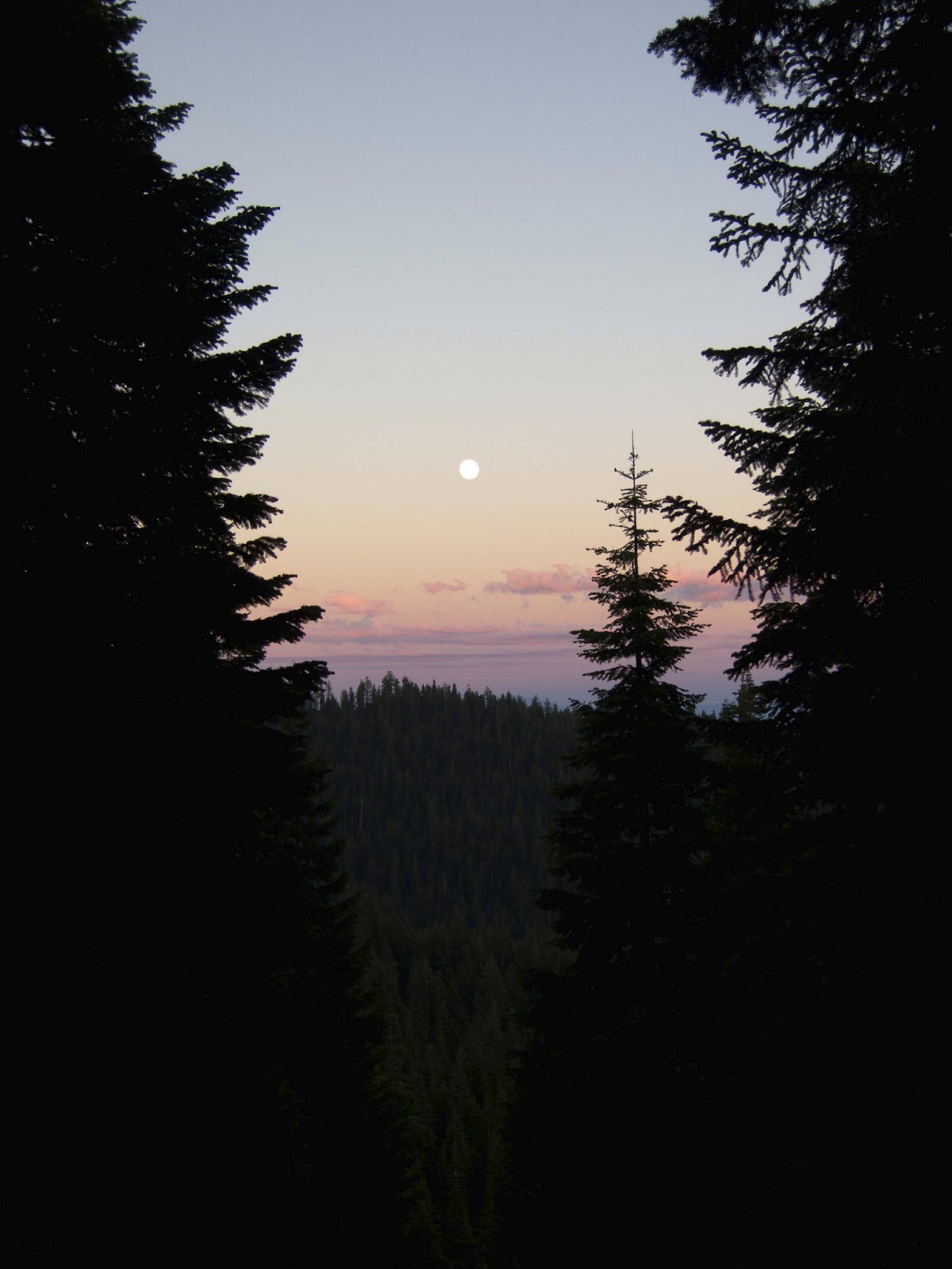 |
| Oregon sunset, climbing Mt. Ashland. |
Which we eventually did. To my chagrin there were hidden ups within
these downhills. It's like 'take me down, I don't want to go up!'
But, we steadily plodded on and made it to where we camped out by
about 11:15pm. We were both pretty damn tired. and immediately said
'screw it, that looks like a good spot' and didn't care how flat it
was and set up camp. I went to be at probably 12:05am after cooking
dinner, getting my plans set for tomorrow and all my food ready. It
was a bit chilly and breezy, even where we were at in the trees. We
woke up and we were kind of on the edge of the fog. We're on a ridge,
so down off to the north is Ashland and that whole valley was filled
with fog, and off to the south where Mt. Shasta is...I can actually
see it right now as I walk, is all clear. We were on the ridge, the
separating line between fog and not fog, so we got a bit of moisture
during the night and it kind of kept it pretty cold, but otherwise,
it wasn't too bad. Today it's just a downhill to the I-5 saddle and I
think I'm going to try for a 50 and get to the hut I stayed in last
year. It's almost 50 miles exactly, so if I stay on it, it looks
pretty flat, I should be able to make it.
 |
| About 5 miles from the OR border looking back S-SW from where we just came - behind the lefthand ridge. |