 |
| View E, Mt. Shasta just visible behind the mountains. |
June 29, Day 36. I made it a total of
50.75 miles to mileage 1583. It was at a saddle by the trail,
actually by where the trail comes off of the ridge and shoots down
into the canyon next to Highway 93...about 5 miles away from Highway
93. That point was 0510763 E 4561531 N. I actually made it there by
11:13pm, which I am really proud about. I hauled ass.. *laughs*.. I
fuckin' made it pretty much 51 miles before 11:30pm. That's.. I'm
happy! Most of the time I'm hiking until 11:30pm and only make it to
48 or 49. So, a little bit ahead of the game. Anyway, I started off
in the morning , it didn't rain overnight. It was fairly clear.
Towards the south there was blue sky and over me it was partly cloudy
and to the north-northwest it was thicker. Not too cold, pretty warm
with good views. Yesterday I camped kind of tucked into some trees on
a ridge next to, or a little bit passed the second road you cross
coming up from the Castle Crags State Park climb. I took off in the
morning and I couldn't... the first couple miles were alright, and
them from like mile 3 to mile 10, I just like was in this haze and I
couldn't wake up. At least it was flat walking, so it wasn't hard
whatsoever, a few little ups here and there, but it's just when
you're in that state, it feels like you're not moving fast. I mean I
made it to mile 10 in 3 hours, which is right on pace. That's what I
judge and estimate my time by: 3 hours equals 10,
 |
| Evening sun after Hwy 4. |
miles. Then throughout the day I can judge how my pace is going. So I made the 10
miles in good time but, which was in-between the Dealfall lakes,
between the upper and lower, and I stopped. I had a Dr. Pepper from
trail magic that I'd carried from the night before. I knew I had to
get out of the funk, get out of the haze, so I had half of it and put
the other half into my water bottle. That strategy worked fine. I had
some cheese and salami and some other snacks to fuel myself. I've
found that after breakfast within the first 10 miles or so, it really
helps to keep your energy up, by giving yourself a lot of fat to
digest. So I fueled up and started hiking over to Park Creek Road and
the trail head there. It was all pretty flat still. I started meeting
a bunch of day hikers. I probably passed ohhh 7 day hikers coming in
from that trail head..it was Friday, so I guess people were making a
long weekend of it. Shasta was directly to my west, or so I believe
was my west, but hiding behind the hill. Finally, the caffeine and
liquid sugar kicked in and I started feeling better, the haze
disappeared. I kind of felt, instead of feeling like I'm struggling
to keep the pace, that I was moving faster. I got across Park Creek
Road and there were some rain showers. Once you cross you have to do
this big huge kind of U-turn above a valley. It's basically a 5 mile
90 degree turn, you even go a little bit back to the south and can
see where you came from, which is really annoying. But, you know
through there, in this little U-turn bowl area...you're following
these hill/mountains that form a bowl...it showered a little bit.
Nothing big. I didn't put any protective gear on or anything. Then it
cleared up after that, and for the rest of the day the skies were
 |
| HDR sunset. |
filled with big white puffy clouds - blue sky and partly cloudy. It
was nice, not very hot. I kept going and going and going and it was
really a flat day. Downhill, downhill, all the way until basically
Highway 3, at which point it, at first it lazily meanders up and then
it continues up at an easy incline for about 8 miles, which isn't
hard, but it's just a long grind. It's not steep enough to make you
out of breath, but steep enough that you don't want to be doing it. I
met another thru-hiker names White Hat or a section hiker I mean, and
another section hiker possibly named Couscous, she's still deciding
if she wants that name. They were just around Highway 3. When I hit
Highway 3, I was at mile 36 and it was about 5pm, which I was happy
about because I knew I was going to go big and go early. So I put it
into high gear, had the rest of my Dr. Pepper, some food, some power
bar energy gel things with a little caffeine in them, so I was
loading myself up, because I knew it was going to be a long and
grinding up. My goal was to hit the ridge line before 9pm. You go by
the Marshy lakes, well you go above them and kind of around this
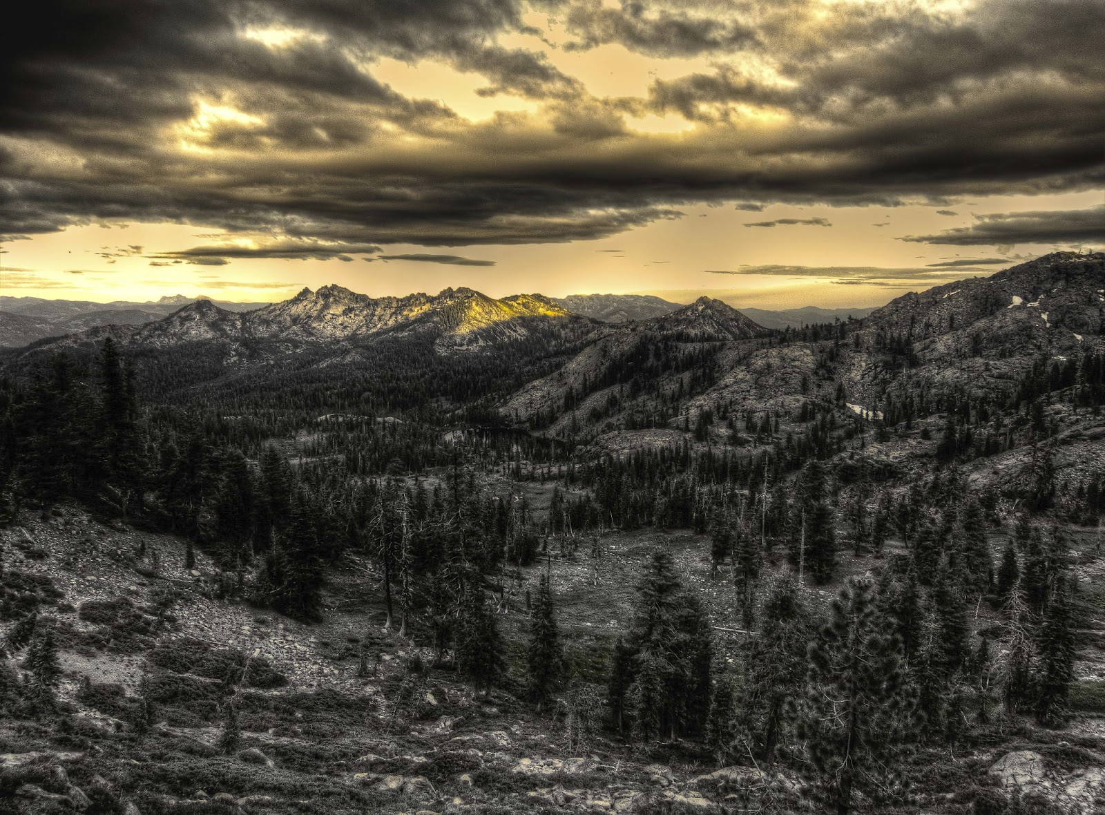
little amphitheater. Because of the clouds, the sunset was pretty
good, there were sun rays coming through highlighting mountains and
kind of this patchwork of sunlight across the open expanses of
forests and mountains. Shasta was wreathed in clouds, back behind me.
I got to the ridge line at 9:01pm, so I was right on schedule. From
the ridge you follow along the back side. It turned dark

and I was
right on schedule. I was hoping I'd get there a little earlier so I
could go to be earlier, but I was happy regardless. My first proper
50 that I could write down. I have done other 50's except for that I
have split them up into multiple days depending on how one defines a
day - whether it's a day or the record or a day as we commonly think
of them (6am-6am for a record 'day' or 12am-12am for normal day).
It's the first one I can record. I hope I can repeat it tomorrow.
We'll see how it goes. The 50 puts me on a good schedule for
hopefully hitting Seiad Valley with the store being open still. I
have my package at the RV park, so it doesn't matter about the post
office, but it would be realllly nice to be able to buy anything,
anything at all for the next segment. So, there was a campsite marked
on Halfmile's map, and that's where I stopped at. I thought I might
actually find someone there because there is a guy called Mouse
somewhere right ahead of me. Doing the math I figured he may be 15 to
20 miles ahead and he probably doesn't hike nearly as late, so I
think I'm whittling down the distance. Otherwise, I didn't put up my
tarp. The sky was just big puffy clouds, partly cloudy when I went to
bed. I figured it wouldn't rain and it did not. In the morning, the
clouds were a bit lower and by about 2 hours I left, I looked back
and the saddle I was sleeping in was socked in with clouds. Good
thing I got up early, well not even that early. I left about 6:40am.
But good thing I got out of there and it didn't happen overnight,
otherwise I'd be wet! That's about it. It was a great day and I am
happy I could pull off that 50.
 |
| Sunset 10 miles after the Hwy 4 crossing. |